Description
Features
Directions
Show more...

| Beds | |
| Price | €125,000 |
| Property Type | Development Land |
| Size | meters2 |
| Energy Rating | BER- |
| Refreshed on | Oct 15, 2025 |
| Eircode | |
| Group Name | REA Spratt |
| Sales License Number | 001621 |
Description
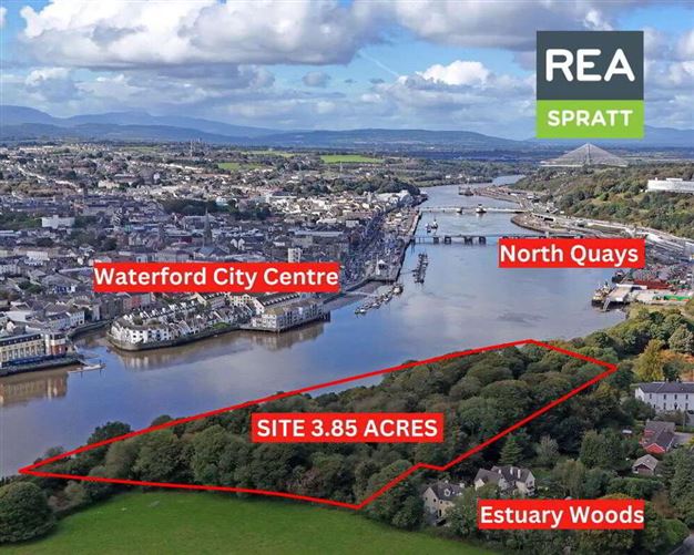
REA Spratt offer For Sale by Online Auction on Thursday the 27th of November at 11am, this is a unique opportunity to acquire a 1.56ha (3.85 acres) site bounding the River Suir. The lands are located in the Christendom area of Ferrybank, and is accessed through the Estuary Wood Residential Development. The site is situated on the North bank of the River Suir, with superb views overlooking Waterford City, the quayside marinas and the recently constructed River Bridge connecting the City Centre to the North Quays Rejuvenation project. The lands are currently zoned under two Development Plans. Part is zoned under the Open Space and Recreation Zoning in the Waterford City and County Development Plan, the remainder is zoned Passive Open Space under the Ferrybank Bellview Local Area Plan. The site would be ideally suitable for a community facility project, recreational facility, and sports or leisure related businesses. Alternatively, Planning Permission may also be sought for a use that is contrary to this Zoning under a Material Contravention planning application. This is a unique opportunity to acquire 3.85 acres within 2.8km of the New North Quays Bridge and City Centre. -Objective to allow for passive open space. Permitted Uses: Agricultural Building, Open Space, Playground. Open for Consideration: Cafe, Car Park, Caravan Park/Camping Site (not permissible within the flood zones), Club house and associated facilities, Community facility associated structures, Cultural/Recreational building, essential infrastructure, Golf Course, Graveyard, Leisure and associated structures, Water?based Recreational / Cultural Activities. Extensions and expansions of existing uses will be considered on their own merits. -Objective for Open Space and Recreation Preserve and provide for open space and recreational amenities. Permitted Uses as set out in code OS within the Zoning Matrix as contained within the Waterford City and County Development Plan. https://waterfordcouncil.ie/app/uploads/2023/09/Waterford-City-and-County-Development-Plan-2022-2028-Vol-2.pdf
Features
https://reaspratt.bidnow.ie/lot/details/163628
Directions
52.25934686563245, -7.09688391849553
Date created: Oct 15, 2025